
Projects
Some of our spatial creations

Melbourne's 3D Zone Analysis
Visualising Melbourne's planning controls in 3D
We were tasked with creating an interactive model of showing Melbourne's height limits and setbacks in 3D.
Terra-Asset

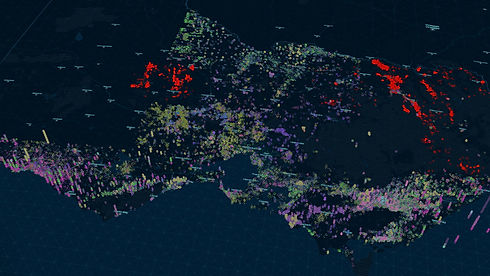

Complete borehole lithology for Victoria visualised in 3D
With over 140,000 historical boreholes across Australia, our mission was not only to map each location, but also to display them in 3D, complete with detailed lithological profiles. The map below illustrates these boreholes, with their proximity to mining sites highlighted in red. This project is a powerful demonstration of how 3D cadastral data can elevate spatial analysis, offering deeper insights and transforming how we understand subsurface information.
AI-Powered Geospatial Insights
Unlock the potential of your geospatial data with our AI-driven analytics solutions. Our advanced technology empowers you to gain valuable insights and make data-driven decisions with ease.
Data Optimization and Visualization
Maximize the value of your geospatial data through our data science expertise. We accelerate data processing, optimize storage, and provide intuitive visualization for comprehensive understanding and actionable intelligence.
Custom Geospatial Applications
Tailored to your unique needs, our geospatial applications offer unparalleled versatility. From mapping and navigation to urban planning and environmental monitoring, our solutions adapt to diverse use cases with seamless integration and exceptional performance.
End-to-End Geospatial Solutions
Experience a full spectrum of geospatial services, from consultation to implementation, ensuring a seamless and impactful customer journey. Our dedicated team is committed to delivering exceptional geospatial solutions that drive success and satisfaction.

Seamless Integration with Your Infrastructure
Our solutions seamlessly integrate with your existing infrastructure, ensuring a cohesive and efficient workflow. Experience the power of advanced geospatial analytics without disruption to your operations.